
Demystifying RTK GPS: The Surveyor’s Secret to Centimeter-Level Accuracy
Have you ever wondered how surveyors pull off the map-making equivalent of brain surgery? Whether they are marking out property lines, grading a massive highway project, or guiding a multi-million dollar autonomous drone, they work with a level of precision that leaves standard consumer tech in the dust.
If you turn on the GPS map on a high-end smartphone, your location is usually accurate to about 2 to 5 meters. That is fine for finding the nearest coffee shop, but if you're laying down a skyscraper foundation, a 3-meter mistake is a multi-million-dollar catastrophe.
To bridge this massive gap, professionals rely on RTK GPS (or more accurately, RTK GNSS). This technology takes messy satellite data and instantly refines it to within 1 to 2 centimeters of absolute reality.
Here is a breakdown of how Real-Time Kinematic positioning works and why it has completely revolutionized the surveying world.
The Core Concept: Code Phase vs. Carrier Phase
To understand why RTK is a game-changer, you have to understand why standard GPS is so imprecise. Your phone tracks satellites using code-phase tracking. It reads a coarse binary digital signal beamed down from space. This signal is easily delayed or bounced around by layers of the Earth’s atmosphere (the ionosphere and troposphere), clock timing drifts, or tall buildings.
RTK ignores the digital code entirely. Instead, it measures the raw carrier wave—the actual physical radio wave carrying that code.
Think of it this way:
-
Standard GPS measures distance using the giant rhythmic thumps of a bass drum.
-
RTK GPS measures distance by counting the tiny, individual sound waves inside that music.
Because a carrier wave has a tiny wavelength (about 19 cm for the standard L1 GPS frequency), tracking its exact phase gives a receiver a blueprint that is inherently 100 times more precise.
The Dynamic Duo: How Base and Rover Work Together
You cannot achieve RTK accuracy with just one device. A standard on-site RTK setup requires two distinct components working together like an elite tag-team:
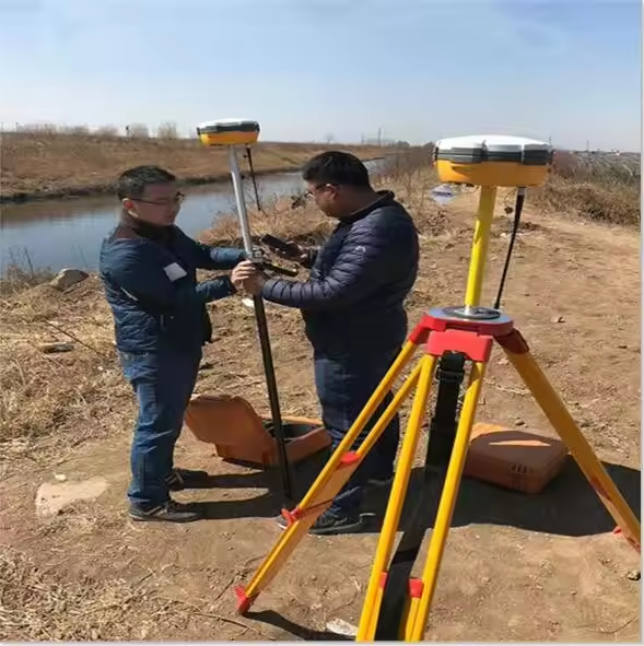
1. The Base Station
The Base Station is a high-grade GNSS receiver placed on a heavy tripod over a completely stationary, precisely known location (like a pre-surveyed benchmark). Because the base knows exactly where it is standing on Earth, it can instantly see the discrepancy between its true location and what the satellites say. It calculates these errors in real-time.
2. The Rover
The Rover is the mobile receiver that the surveyor carries around on a pole, mounts onto an excavator, or attaches to a mapping drone.
3. The Communication Link
The Base Station continuously broadcasts its real-time error corrections to the Rover. This data transmission happens through either localized UHF/VHF radio frequencies (best for remote sites without cell coverage) or via the internet using a cell network protocol called NTRIP.
The Rover receives its own satellite data, applies the real-time corrections from the Base, cancels out the atmospheric distortions, and instantly outputs its exact coordinates.
Knowing the Status: Single, Float, and Fix
When looking at a surveyor's data controller screen, you'll see three primary tracking states:
SINGLE: The rover isn't receiving corrections. You are at standard smartphone accuracy (meters).
FLOAT: The rover is receiving base data, but the algorithms haven't fully solved the complex math of the radio waves yet (decimeters).
FIX: The math is solved! The receiver locks in. You are operating at true centimeter-level precision.
RTK vs. Alternative Positioning Systems
Standard GPS / GNSS
While standard GPS delivers instant data right in the field, its accuracy is limited to 2 to 5 meters. Its hardware requirements are minimal, usually needing just a single device like a smartphone or a basic handheld tracker. This makes it perfect for casual navigation and general tracking, but completely inadequate for precision engineering.
RTK (Real-Time Kinematic)
RTK scales that precision down to a razor-sharp 1 to 2 centimeters, delivering results instantly while you stand in the field. To achieve this, it requires a synchronized hardware ecosystem consisting of a Base Station, a Rover, and a live radio or cellular internet link. It is the go-to choice for staking out property boundaries, active land grading, and precision construction.
PPK (Post-Processed Kinematic)
PPK matches the 1 to 2-centimeter accuracy of RTK, but with a catch: the data delivery is delayed. Instead of live corrections in the field, the raw data must be brought back to an office computer for post-processing software to clean up. The hardware setup requires a Base and a Rover, but it eliminates the need for a live, real-time communication link. This makes it ideal for drone mapping in remote areas where radio signals or cellular networks are completely non-existent.
The Limitations: Where RTK Struggles
As magical as RTK seems, it isn't completely invincible. Because it relies on tracking clean, fragile radio carrier waves from outer space, it struggles in environments prone to multipath errors—where radio waves bounce off surfaces before hitting the antenna.
If you take an RTK rover deep into a dense forest canopy or into a tight urban environment surrounded by glass skyscrapers, the signals get scattered. When this happens, the system drops from a "Fix" to a "Float" or "Single" state, and the precision drops right along with it.
The Future: Network RTK (VRS)
*Setting up your own physical base station on a tripod every single morning can be tedious. To solve this, governments and private tech networks have built Network RTK.
*Instead of buying your own base station, hundreds of permanent, continuously operating reference stations (CORS) are scattered across regions. Surveyors can simply turn on their rover, connect to the local network over a 5G cellular link, and stream correction data from a "Virtual Reference Station" nearby.
*Whether it is building bridges, mapping utility lines, or automating tractors, RTK GPS has transitioned from an expensive luxury to the literal backbone of modern spatial industry. It has taken the guesswork out of positioning, ensuring our digital maps align perfectly with the physical world beneath our feet.
.webp)

.webp)